Texas Is Bigger than…

You may have seen a meme (the idea kind of meme, not the image macro kind) going around comparing states of the northeastern U.S. to urban areas of Texas, like this one showing that Connecticut is about the same size as Houston:
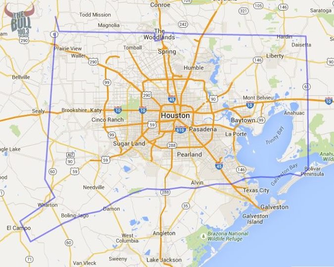
Via The Bull / Facebook

Via The Bull / Facebook

(h/t G)

I found a site (MAPfrappe) that lets you do this by tracing outlines on the map, then dragging them around for comparison’s sake. It even adjusts your outline to account for the Mercator projection. I used it to make an outline of Oahu to show that it’s about the same size as Austin, but then wondered why I spent time doing that when I could have traced Texas in order to compare it to other places around the world.

You can use my outline to compare Texas around the world, too, but here are a few comparisons: Continue reading

Share

There Is No More Boot

Printed maps of the state of Louisiana typically show a “L”- or boot-shaped state, but the state hasn’t actually had that shape for quite some time (h/t PZ):

According to the U.S.G.S., the state lost just under 1,900 square miles of land between 1932 and 2000. This is the rough equivalent of the entire state of Delaware dropping into the Gulf of Mexico, and the disappearing act has no closing date. If nothing is done to stop the hemorrhaging, the state predicts as much as another 1,750 square miles of land — an area larger than Rhode Island — will convert to water by 2064. An area approximately the size of a football field continues to slip away every hour. “We’re sinking faster than any coast on the planet,” explains Bob Marshall, a Pulitzer-winning journalist in New Orleans. Marshall authored the series “Losing Ground,” a recent collaboration between The Lens, a non-profit newsroom, and ProPublica, about the Louisiana coast’s epic demise. Continue reading

Share

Test Your Geography Knowledge!

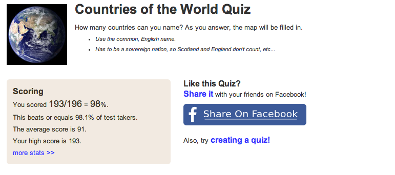
This one’s a doozy. No multiple choice or “find X on a map.” You just type in the name of every country you can think of in twelve minutes (h/t Kerry).

Screen Shot 2014-04-10 at 11.06.00 AM

I got all but three, although not many people get those countries right on the test: Antigua and Barbuda (12%), São Tomé and Príncipe (7%), and Fiji (29%). I can’t believe I forgot Fiji! My brain must have frozen or something.

Spelling can be an issue, too. I got lucky on Kyrgyzstan and the Philippines (one “l”), but kept misspelling Guatemala.

(I should note that I’m kind of a showoff about this sort of thing. None of my friends will play Trivial Pursuit with me anymore.)

Share

Texas is #26!!!

Today’s random Texas statistic: this is the 26th-largest subnational governing body, as measured by area, in the world.

Alaska clocks in at #7, and I doubt anyone is ever going to overtake the winner, Russia’s Sakha Republic, which takes up a large percentage (about 24%) of Siberia. You could fit roughly 4½ Texases in the Sakha Republic. On the other hand, the greater Austin area has more people than the Sakha Republic, so we might be evenly matched in a game of pick-up basketball.

Yeah, that's, uh, big.

Yeah, that’s, uh, big.

In terms of population, Texas’ 25 million people rank 5th in the world among subnational units, behind China’s Sichuan and Heilongjiang Provinces, the state of California, and Gansu Province in China. Canada’s Nunavut, which ranks fifth in land area, ranks last in population with just over 33,000 people.

Photo credit: By TUBS [CC BY-SA 3.0], via Wikimedia Commons.

Share

Today in Epic Body Art, World Traveler Edition

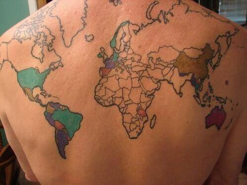
A long time ago, I blogged about a German woman who had an old map of the city of Hanover tattooed on her back. This might be even more epic (h/t Mike):

I see Paris, I see France.... Nope, that's all.

I see Paris, I see France…. Nope, that’s all.

According to the Facebook page True Activist, “every time she goes to a country she gets it colored in.” While I think this is a pretty sweet idea, I have a few critical comments:

– She used the Mercator projection, which she didn’t need to do, considering that her back is a curved surface. The Mercator projection was a clumsy attempt to transfer the not-quite-spherical world map to a flat surface, making the Northern Hemisphere, and the Arctic region and Greenland in particular, seem much, much bigger than they actually are.

– She hasn’t updated her map to show the independence of South Sudan. Either this picture is at least two years old, or she is not attuned to the political upheavals of summer 2011. I can’t really tell, but it looks like she may have acknowledged East Timor. Let’s not even get started on Abkhazia, South Ossetia, Nagorno-Karabakh, or Transnistria, though. In fact, the Caucasus part of the map only has two countries, when there should be at least three. Continue reading

Share