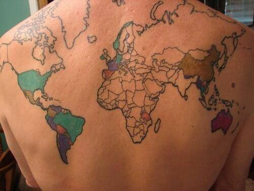
A long time ago, I blogged about a German woman who had an old map of the city of Hanover tattooed on her back. This might be even more epic (h/t Mike):

I see Paris, I see France…. Nope, that’s all.
According to the Facebook page True Activist, “every time she goes to a country she gets it colored in.” While I think this is a pretty sweet idea, I have a few critical comments:
– She used the Mercator projection, which she didn’t need to do, considering that her back is a curved surface. The Mercator projection was a clumsy attempt to transfer the not-quite-spherical world map to a flat surface, making the Northern Hemisphere, and the Arctic region and Greenland in particular, seem much, much bigger than they actually are.
– She hasn’t updated her map to show the independence of South Sudan. Either this picture is at least two years old, or she is not attuned to the political upheavals of summer 2011. I can’t really tell, but it looks like she may have acknowledged East Timor. Let’s not even get started on Abkhazia, South Ossetia, Nagorno-Karabakh, or Transnistria, though. In fact, the Caucasus part of the map only has two countries, when there should be at least three.
Anyway, this sort of tattoo is really only worthwhile for a true world traveler. Mine would be mostly blank, except for North America and western Europe. I’ve been to Russia, but somehow it wouldn’t seem fair to count the whole country when I never went east of Moscow.
For gits and shiggles, here are the countries I’ve visited and when, as best I can remember (dates may be approximate):
- Canada, 1985
- United Kingdom, 1986, 2000
- Cayman Islands, 1988
- Belize, 1990
- Sweden, 1992
- Finland, 1992
- Russia, 1992
- Belarus, 1992
- Denmark, 1992
- British Virgin Islands, 1993
- Mexico, 1994, 1995, 2012
- France, 1997
- Spain, 1997, 2000
- Monaco, 1997
- Italy, 1997
- Switzerland , 1997
- Germany, 1997
- Luxembourg, 1997
- Iceland, 1999
- Canary Islands, 2000 (politically part of Europe, but geographically part of Africa)
- Ireland, 2000
- Turks and Caicos Islands, 2013


A nitpick from a map geek. The Mercator projection is not a clumsy attempt to transfer the globe to a flat surface – any flat map of course requires such a feat – it’s just misused. The Mercator is a work of genius for its intended purpose: marine navigation. Any straight line between two points on the Mercator represents the shortest path between those points on the globe, so it makes it really easy to find the best path at sea to your destination.
It was never intended to accurately represent area – there are many other projections better suited to that purpose. Mercator himself used a different projection (the sinusoidal) to show areas accurately.
You’re right, of course–my writing style tends towards the sarcastic. I apologize to Mr. Mercator and his legacy, because he was pretty revolutionary. Thank you for keeping me honest